Follow our journey across New Zealand's South Island.

Friday, January 11, 2013

The Best Laid Plans


Thursday was one of those days that you couldn't make up if you tried. But as the saying goes, you earn your anecdotes – and we certainly earned our fair share all at once.

The rain finally arrived overnight. At about 2 a.m. our slumber was drowned out by sheets of water on the roof of the little house in Nelson Lakes. It was one of those rains that covered your dreams and lowered you into a deep sleep. We awoke at 7 a.m. to gray clouds and misty skies. At this point, we didn't mind having a washed out travel day, because the next day was guaranteed sunshine.

We had breakfast with our gracious hosts, said our goodbyes to the animals and were out the door at little after 9 a.m. All of the views of St. Arnaud from the day before were hidden in clouds, so it was easy to speed out of the village without looking back. Soon, I dozed off and Dave settled in for his 1.5 hour drive to the city of Nelson. Our plan was an early lunch before catching our 2:30 boat to the wilderness lodge where we planned to spend the next three days.

Leaving the St. Arnaud B&B in Nelson Lakes.

After waking up from my car-induced nap, we noticed a sign that said 100km to Nelson – which didn't make any sense at all since we had been driving for about an hour already. We had been driving through rolling hills and vineyard after vineyard. I whipped out a map to see why everyone had misjudged the length of our drive. That’s when I discovered we had gone the long way around. While I was dozing, and Dave was following the signs to Nelson – we missed the shortcut north to set us the right way around the loop. Instead we drove to the East coast and up, unfortunately adding an extra hour to our trip. No big harm done. We kept speeding along through the muted mountains and wineries. I just felt badly for Dave who now had to drive longer than planned.

Following us along this extra journey was the rain and wind. Big gusts were swooping down across the road, turning trees aside and tampering with trucks and camper vans. We had heard radio reports of gale force winds and we were experiencing them firsthand.

We pulled into Nelson around noon – an hour behind schedule. We didn't have time to linger, so we took a slow roll through downtown to look at all of the shops and cafes we’ll have to choose from on the return drive on Sunday. From there, we continued our drive North to the national park of Abel Tasman. The closer we got to the coastal park, the better the weather turned. Blue skies and puffy white clouds. We started to feel the pull of the beach.

An hour or so later, we reached the small beach town (really too small to call a town) of Kaiteriteri where we were schedule to pick up our water taxi to our lodge. We saw clouds on the horizon, but our skies were blue. We sat at a roadside stand and ate the largest pile of fish and chips wrapped in paper, ever. As we plowed our way through the fried goodness, the clouds caught up and it started to mist. Apparently just a tease of what was to come.

Delicious fish and chips.
At 2 p.m., we went to check in with the water taxi company. By the time we pulled up to the stand, the mist had turned into a downpour, and the wind found us. Dave jumped out of the car to get our boat tickets. I watched him talking to the woman at the counter. Heads were shaking back and forth. Maps were taken out. Dave was in deep discussion. He looked at me and shook his head. My heart started beating fast.

The news was mixed. The Tasman Sea was angry. Wind was bad. Waves were high. No boats could take us to Awaroa Bay to our hotel until tomorrow. Big apologies. “First time we can remember when a boat couldn’t go in there.” Great. But if we wanted to get to our hotel we had one option. The boat could drop us off at a more sheltered beach an hour walk away. We could pack an overnight bag, hike in, and they would bring our bags the next morning. Deep breaths. It was a change, but not the end of the world. We could do this.

We had 30 minutes to sort our bags. The rain was steady, the wind a mess. Dave and I climbed around in the back seat of the car repacking bags, digging out jewelry, electronics, camera equipment, toothbrushes, bathing suits, sunscreen. Changing into hiking clothes for the trek in. We got it done. No storm would stop us.

We watched the sea as we waited for our boat. The waves climbed and the wind roared. The boat was running late. By 2:45, a small catamaran power boat appeared on the beach. The surf was too rough to go to its normal landing spot, so we hiked down the beach to meet it. They lowered a ramp that did not want to rest quietly on the beach. It lurched up and down, in and out of waves. We took off our shoes and made a run for it. This was not going to be a dry day.

About to board the boat. Notice the skipper trying hard to hold the ramp down and the person who just ran off of it in the black fleece behind me.


The boat took off like a roller coaster through the waves. The little boat chugged along. It was a dance for the entire ride. Sometimes we stayed steady, and sometimes the waves won. The family and the other couple on the boat were sightseeing (not a great day for it). So as we worked our way up the coast of Abel Tasman National Park, we even took time to pull up alongside the shore to wave hello to some seals. The seals looked back at us like we were nuts. Rain pelting our faces, boat pitching, cameras flashing.
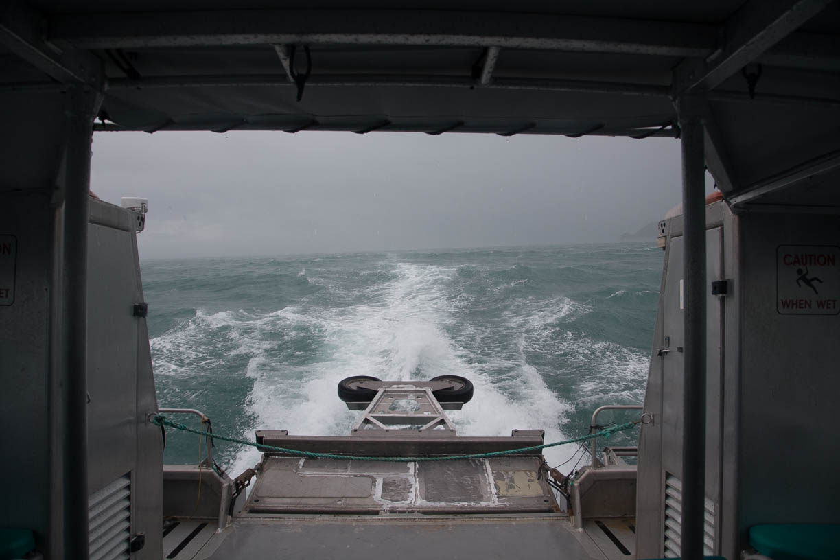
Bumpy ride.

We pulled into one beach and picked up a handful of soggy hikers – and then continued North. About 20 minutes of very rough seas later, we pulled into another beach right next to a companion boat. The skipper announced, no more sightseeing North. Please get off the boat here and board the other boat to head South to get back to your cars. But to us he said, sit tight. We’ll take you to your drop off point about 20 minutes  North. Great.

The angry Tasman Sea.
Dave and I started gearing up. Water shoes, check. Rain coats, check. Backpacks covered in waterproof plastic, check. Rain ponchos that looked like giant white garbage bags, check. Were we nuts? Check.
They told us they would get us to the far side of the beach near the trailhead. Sure, thanks. Whatever you can do. We motored toward shore. What a crazy ride in through the breakers. They couldn’t get really close in on the beach because of sand bars and the waves. They lowered the walkway down into the water. It bounced and rolled. Not quite a red carpet.

Dave got off first. Water above his knees. I jumped in behind him. Water almost to my waist. I hiked up my shorts, lifted my backpack – and we started the crazy journey through the surf and up the beach. The boat started to pull away. Within moments it would just be the two of us. Middle of nowhere, rain coming down sideways, up to our waists in sea water. Five star wilderness resort an hour away. Sure, no problem. We trudged up the beach, the sand stung and we could look nowhere but down. A few minutes that felt like a lifetime later, we reached the edge of the bush.

I’m not going to sugar coat, when my feet went off the ramp and I sunk down almost to my waist in the surf, there may have been a tear or two. And a “WTF am I doing?” moment. But within seconds, it was laughter. Memories were being made, and it was all going to be okay.

We put our shoes on and dug in for the haul on the trail through the bush. At least the trail was really well maintained, and at that point, I didn’t care about the several inches of water to walk through. I wish there were pictures of us in our white trash bags, wind blowing the stinging sand, tears, laughter, thunder overhead. But you’ll just have to take my word for it.

By the time we reached our lodge an hour later, we were covered in mud and sand, and in a really good mood. Music thumped from the speakers, wine was being poured, we left one world and emerged into another. Gracious reception desk, very matter of fact. “Oh you poor things, you need a hot shower. What time would you like to have dinner?” We had made it.

The Awaroa Lodge in Abel Tasman National Park – a little slice of paradise in the middle of the bush, on a beautiful coastline with no roads. Only a hiking track, a boat ramp and a helipad. Apparently the front desk had been a mess all day with people who couldn’t get in, couldn’t get out. It appeared that everyone else wasn’t as amenable to trudging an hour in the bush with overnight packs!

We got to our room, showered and took long, hard naps. By 7:30 p.m. we arrived to an amazing dinner. The skies were clearing, SUN was starting to come out and we had a table on the back veranda over an incredible view of the wetlands. I had a lamb salad with mixed greens, and red grouper over prawn risotto. Dave had a seafood chowder, and venison with red cabbage relish and a kumara cake (New Zealand sweet potato). For dessert, we shared sticky date pudding with butterscotch sauce and vanilla ice cream.

Worth the adventure. Our room at the wilderness lodge.
As an added treat, we were graced by the presence of a professional opera singer from Australia, who just happened to be joining us for dinner at the resort. She was persuaded to provide us with an impromptu show. We dined on an exquisite meal in the middle of the New Zealand wilderness surrounded by the crystal clear voice of an opera diva singing from The Marriage of Figarro. For a few minutes, I forgot who we were. 

It should go without saying that we slept well Thursday night. And we had nowhere to be until 9 the next morning. In fact, we were in the middle of nowhere, so really, we had nowhere to go at all. We went to bed happy with the culmination of the day. Sometimes the best laid plans fall apart and make way for the best memories. 

Wednesday, January 9, 2013

Above the Tree Line

We woke up cozy in our cabin in the woods and joined the family for breakfast at 8:30 a.m. Freshly made muffins, granola, fruit and yogurt and morning conversation around the kitchen table fueled our day ahead. Staying here is very familiar, as if we are visiting distant relatives - comfortable on the couch with a book and a cat (and another cat and a dog) and sharing family stories.

The skies were clouded over and rumor is that big storms are headed this way. We were a little nervous to be rained on again, but we decided to move ahead with our planned hike for the day. We bundled up and left the house and wereon the trail by 11 a.m.

Today's plan was to hike Mount Robert - over Lake Rotoiti- and it expanded from there. The top of the mountain was clouded over, but we headed up anyway. From the start, it was up and up and up with steep switchbacks. The nice thing was that the mountain was open so we had gorgeous views in all directions as we sidestepped the incline. We would go in and out of trees, but mostly we worked our way up an open mountainside, quickly rising away from the lake down below. The wind was blowing with strength and we were headed for the clouds above.

The trail wrapped around to the backside of the mountain into the trees. We were serenaded by strange sounds, like instruments, as the trees squeaked against each other with the wind gusts. The switchbacks continued for awhile under the canopy as we approached the summit. 

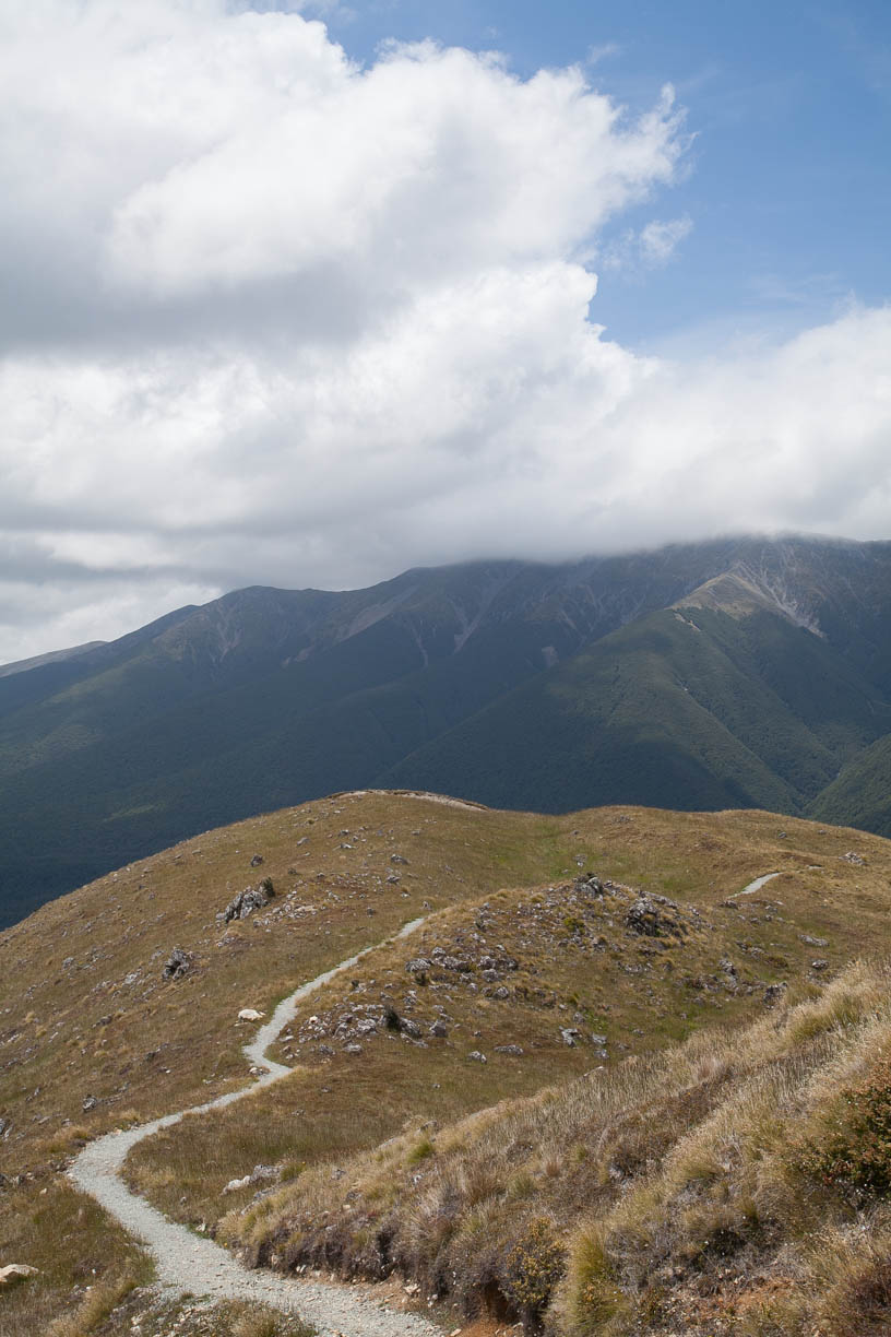
Within an hour of climbing, the trees opened up and we reached the tussocks of the open tundra. The wind roared and we put our fleeces back on to stay warm. We continued the climb up for about 20 minutes until we reached a hut at the summit of the ridge. We were still under the clouds, as they had lifted up to a higher ridge. From where we stood we had beautiful 360 degree views of the lake, rolling farms and alpine peaks. 


After taking it all in for few chilly minutes we started to work our way back down the backside of the mountain. The trail was incredible, complete open tundra in all directions. It felt like the top of the word. The path stayed above the trees almost the entire way down on the back side. As we walked, we noticed the lake getting bluer as the clouds thinned and the sun fought through. Despite the forecasts, the sun seemed to be fighting away the gray. Before we knew it, we were in complete sunshine and stripping our clothes back down to the bottom layer.


The trail down was gorgeous, it snaked its way across golden ridges and balanced high above the now turquoise lake. As we approached the treeline again, Dave and I pulled out the map and decided it was too beautiful to stop hiking at the end of this trail. So we added to it. We decided to take the cut-off down toward the lake. If we walked around the lake for awhile, we would reach the Whisky Falls. 


We got to where the trail split and headed straight downhill toward the edge of the lake. Then we walked right along the lake's edge for 4 km - now taking in the mountain views from another perspective down below. We had to cross a number of large and small streams (each of us had one foot soaking incident, so we each had one squishy foot and one dry one). 

The mystical Whisky Falls were hidden in a small cove in the forest, sheltered by trees. You come up a hill and around a corner and there was a giant downspout catching the light and pouring down onto the rocks below. We stayed as long as the sand flies let us and then walked down to a small boat dock to sit and rest our legs for a few minutes. We hadn't seen another person in hours. The sun was glistening, the water was Caribbean blue and the breeze kept us cool and relaxed. It was one of those moments you never wanted to end. But we had about 2 hours left to hike, so we pulled ourselves away from our short nap on the dock and started our tramp home.

Surrounded by birds as we walked along the lake.

The mystical, hidden, Whisky Falls.

Our private dock - a moment that we didn't want to end.

Unfortunately the final stretch (after we made our way back around the lake) was up and up, just the opposite of what our tired legs needed. But we powered through. Six long hours after we left our car that morning - six long hours and 11 miles of fairly quick hiking with lots of up and down - we were back at the car and ready for food and rest. 

There was not a cloud in the sky. The day had fooled the weather forecasters and we weren't complaining at all. We stopped down at the dock at the North end of the lake in St. Arnaud and spent some time on the dock watching the kids jump into the cold, cold water. It was at that point that we looked down and noticed the giant eels (yes, eels) loitering below the dock. Apparently the local children didn't mind them at all. 

The "main" dock in St. Arnaud. Mount Robert is on the right. We were standing up there earlier that morning. On the left is parachute mountain.


Yep, eels.

We arrived back at the inn around 6:30 p.m. and reunited with Russell and Marjorie. After a quick shower and change we joined them in the living room for cheese, crackers, fresh mussels and beer - sharing details of our day. Marjorie and her daughter Melinda were busy cooking dinner in the kitchen. Soon, we all sat down for lamb roast with mint jelly, potatoes, peas and corn, broccoli with cheese sauce and roasted carrots and sweet potatoes. They all joined us at the table and it was a family meal without the family - just new friends. Dessert was a sweat cream custard with fresh raspberries and powdered sugar. 

Now, we're relaxing in the living room. Windows open, the sun just went down. The rain is still on its way - but it's not here yet. Russell and Dave are sampling beers and talking about antique boats and planes. Marjorie is plugging away at a crossword and Melinda is deep in a book. It's nice to go away on vacation and feel at home. 

Tomorrow we leave St. Arnaud and continue our trek North. I'm looking forward to getting on a boat and leaving our car behind for three days. More to come on that soon. But for now, I'm off to continue being cozy as we wait for the rain to arrive. 

St. Arnaud B&B. Our home away from home.

Tuesday, January 8, 2013

Heading North


Today we continued our trip to the Northern parts of the South Island. We slept well, especially after being up late the evening before with Dave and Rina at the Misty Peaks. Overnight it poured with rain, we heard it on the roof just an hour or so after we went to bed. So we figured we’d wake up to the return of clouds. But it was another blue sky day by the time we emerged at 8:45 a.m. for breakfast. Misty Peaks Dave made us fried eggs, mushrooms and grilled tomatoes, and loaded us up with fruit, granola and yogurt. Then, after four lovely days, we packed up our stuff (again) and got ready to hit the road. Misty Peaks was definitely a highlight of our journey. It really felt like home there, curled up on the couch with books, sitting in the kitchen with wine and cheese, relaxing on a bench outside writing the blog – and great conversations with Dave. We learned so much about New Zealand, and we shared lots of notes about politics, travel and sports. It was really tough to leave – in fact, it was so difficult, that we all ended up chatting again today until 11 a.m. When, not if, we come back to New Zealand, Misty Peaks will be a place where we’ll return.


The Misty Peaks

 We were on the move again, heading North along the Western spine of the Alps – passing lakes, bridges, gorges and mountains along the way. Every once in awhile the sea made an appearance in the distance as we drove along the coast line. About an hour after we left, we reached the notorious bridge that had been washed out a few days before – stopping all traffic up and down the West coast. It was a disaster for the local businesses, but a respite for us. Fox had been basically empty the few days we were there since no buses could come through with the bridge out. We had felt like we had the run of the place. Of course, if the bridge hadn't opened today we would have either have had to stay an extra day in Fox and forfeit our night in Nelson Lakes or drive the really, really long way to get there (15+ hours likely). So last night, when the local rubbish man told Misty Peaks Dave that the bridge was opening ahead of schedule, we breathed a sigh of relief.

Because it is the only way up and down the West coast, they needed to rebuild it in a hurry (it took about a week). They didn't have time to bring in a new bridge, so they piled gravel in the river and built the road across it as a temporary measure. We passed over it without ceremony today, but definitely gave friendly waves to the workers on site who saved the second half of our vacation.

Thank goodness it reopened.

By about 1 p.m. we reached the city of Greymouth (aptly named because it sits at the mouth of the Grey River). We found a little café (DP1 Art Café) and had paninis for lunch.  From there, the road edged its way out to the coastline. All of a sudden, it was warm, sunny and tropical. The road twisted and turned along the rocks looking out across an expansive and very active ocean.

We reached the famous Pancake Rocks – a national park with coastal haystacks and rock formations that have somehow shaped into layers that look like stacks of pancakes. It was fun to wander through and watch the waves ripping through the rocks, slowly softening the defined lines of the sculptured stone.

The pancake rocks on the West coast.

Next we drove another 15 mins until we reached the entrance to the Truman Track. We hiked down to a small secluded beach that seemed to squeeze the mighty waves up and onto the shore. The tide was definitely coming in and you could sense the power of the ocean hitting the sand. We relaxed in the sunshine on the beach for awhile and found ourselves mesmerized by the onslaught of waves.


By then it was 5 p.m. and we had decided to have dinner on the coast before heading the final two hours inland to our next hotel. We drove North another hour toward Westport and arrived at a restaurant that I had discovered through research online – the Bay House.

The Bay House is tucked away on the tip of a peninsula immediately South of Westport. You wouldn’t know it was there unless you knew it was there. We were early enough in the evening that they were able to seat us for dinner without a booking – despite their fully booked night. It was a lovely meal overlooking the sea. I discovered a wonderful new Riesling (Greystone) that I loved through both of my two glasses full. Dave had melt-in-your-mouth fried risotto balls followed by grilled snapper on coconut rice (his meal won). I had tiger prawns on coconut rice followed by chicken breast with a rosemary chili sauce and cranberry cous cous.  It was a delicious meal, but we had to race off before coffee and dessert because the next two hours of driving still loomed before us.

View from dinner.

Wonderful wine, beautiful view.

The Bay House restaurant.

A little action outside the window at dinner. Millie the cat versus one of New Zealand's wingless birds. They actually got along okay.
We drove straight through from there. The roads took us inland toward the Northern edge of the Southern Alps. The further we drove, the fewer and fewer cars we saw in either direction. It became obvious that this is not a highly visited part of the island. It was a peaceful, alpine drive through river gorges and tamed, green, rolling mountains and lakes. As the sun set in the clear sky, stars started to show themselves, but people were scarce.

Slightly before 10 p.m. we arrived in the village of St. Arnaud on the edge of Nelson Lakes National Park. We had let the innkeepers at the St. Arnaud B&B know we would be arriving around 9 p.m. and I was feeling badly arriving an hour later. It apparently didn't matter at all. We pulled up to the cottage in the woods, down a long gravel driveway, and we were instantly greeted by Russell, the owner. He brought us in and told us to leave our things in the car so we could relax and chat a bit. Inside we were introduced to his wife Marjorie and her daughter who is here visiting from Auckland. And then very soon after, we were introduced to our new friends Ruby the dog and Pug and Chili the mother/daughter cats with fur as soft as silk. All of us (animals included) settled into the couches with tea and coffee and got to know each other until midnight. Wonderful, friendly people. We’re the only guests here tonight and, as it always seems to here in New Zealand, it already feels like home.

Now we are settled into to our cozy room and drifting off to sleep. I’m excited to see what the morning sun reveals to us tomorrow here in Nelson Lakes. I think it’ll be time to head back up into the mountains. 

Monday, January 7, 2013

A Day Off

Today we took a brief vacation from our vacation. We had a lovely breakfast, lunch and dinner. Did some laundry. Read a lot on the couch in living room. Drank wine with the other guests. And we closed the day by spending three really enjoyable hours drinking more wine and chatting with Dave, who runs the B&B and his friend Rina who is a local landscape photographer. It was a great day to recoup and relax. We didn't take any pictures, but we cleared our heads and rested our legs.

Tomorrow morning we head North along the coast to Nelson Lakes. Which is good news, because for the last week the road North (the only road North) has been closed because a bridge washed out in last week's storms. We haven't mentioned it here, because we were ignoring it and hoped the problem would go away before it became a real problem. And it did - the road reopened today. So tomorrow, the adventure begins anew. Tonight, we're off to bed and feeling a little sad about leaving the Misty Peaks. This will be a place we will return to someday.

Sunday, January 6, 2013

Vines, Roots and Views

Yesterday lasted from sunrise to sunset - which in New Zealand in the summer is a very long span of time. Despite a very late evening, Dave stuck to his plan of getting up to watch and photograph the sunrise at one of the country's most scenic spots, Lake Matheson. The lake is famous for its mirror-like surface in the early mornings and late evenings - mirrors that just happen to reflect New Zealand's tallest mountains perfectly. I had been up until 2 a.m. finishing off the previous day's blog posting, so I wimped out on the early morning adventure. All I can remember is sleepily saying "have fun" as Dave headed out into the darkness. Apparently he was the only one at the lake and he hiked about 40 mins to find the perfect spot. A few hours later he returned with his treasures - photos that took my breath away.


Dave crawled back into bed for about an hour, and we both made it for breakfast around 8:30 a.m., joining the two couples from the UK that we had dinner with the night before. One couple was heading south to Lake Wanaka and the other was heading up to the glacier for a half day guided hike. Dave and I decided that we were going to hike Mt. Fox, next to the glacier and the high peaks, because it was supposed to have some incredible views of the mountains and the river valley, all of the way out to the ocean.

The trail started right outside of town. We should have been thrown off by what we read about the hike, but we weren't. It was 7km round trip. But it climbed 1000 meters (or 3000 feet). Estimated time, 8 hours. Those signs had been conservative thus far, so we jumped right in. We knew right away that this would be tough hike. The trail was muddy and narrow and it snaked through really wild rain forest. Very different than any place we had hiked before. Beautiful, lush, tropical green - a jungle without the humidity or bugs. The trail meandered for about 20 mins until suddenly, very suddenly, it went up. Not switchback up, but up. We attacked it head on. Imagine climbing extremely steep stairs, with each step about three times as high as your typical step. But those steps are roots and rocks, with mud in between them. It was a Stairmaster workout on steroids. The trail was so steep, you could almost look at it at eye level in front of you. There were sections that we were climbing roots like we were scaling walls of rock on a mountainside. If you can call a jungle trek technical, like a rock climb, this was technical. But it was fun and a challenge. The roots made climbing really easy. There was always a foot hold or a root to grab on to to pull yourself up.


We climbed like that - hot, muddy and exhausted - for about 2.5 hours. It was rough, but it was also fun because we had never done anything like that before. Finally, we got to a section where we knew we were up on a ridge line and the brush got shorter so we could start to see over it. And what we saw is that 2.5 hours later, we were probably about 4/5 of the way to making it the nearly 2 miles to the top. I think we reached the first, lower, summit. There was a survey marker there and incredible views. But we could see that the ridge took another steep turn up into the bush before reaching the real summit. At least another 30 or 40 mins straight up (which meant another or 30 or 40 mins added to the down). At that moment, covered in mud and exhausted, and anticipating 2-3 hours already climbing down - we decided that these beautiful views of the river valley and mountains would suffice and that we were taking a rest and heading back down.


The Fox Glacier river valley, draining out into the Tasman Sea.

The trail continued, but our stamina did not.

And so we started the "climb" back down - picking our way through the roots and vines. Lowering ourselves down over overhangs and steep inclines. Using our arms to hike almost as much as our legs. Dave and I got into a rhythm and, to be honest, despite the labor, it was extremely therapeutic to be focused so intently on a single task for a few hours. We were very quiet, except to talk ourselves through some of the more difficult descents. For stretches on end, the only sound were the extraordinary songbirds with out-of-this-word calls. The birds seemed to be following us down another the path - either cheering us along or wondering why the heck these humans were putting themselves through all of that work.


When we stumbled out of the trail and arrived back at the car 5 hours later (at 3 p.m.) all I wanted was a burger and an adult beverage. So, covered in mud and trying to get used to walking on flat ground again, we arrived in town and sat at a table in the sunshine and gorged ourselves on lunch, beer and hard cider for me. Very rewarding meal.

Muddy and exhausted at the end of the 5 hours.

From there, we decided to go drive to the base of Fox Glacier and check out the giant from it's bottom edge. We drove up into the glacier gorge as far as we could go along the river (which is the melt drainage from the glacier) parked the car and started the 30 mins hike to the edge. My legs were screaming at me for doing another hike, but the day was still young and there was more to be seen.

The pouring rains of the last few days (while we were at our last stop) had messed with the hike up to the glacier. Apparently it had been closed for a few days and there were rock slides and the river had moved. We saw the bulldozer parked that had created a new trail over the last few days for tourists to come in and glacier watch.

The glacier is huge, and it's alive. It's very difficult to explain its scale, but it was fascinating to watch. Every few minutes another chunk, large or small, would break off the end of the glacier and come crashing down with a thunderous, boom. And then a few minutes later, giant ice chunks would come bouncing down the silty river (which is usually blue, but has been running gray with silt this week because of last week's rains). You could here the boulders of ice barreling down the water, hitting rocks as they headed out to sea. It was like watching geology at work in real time.

The bottom of the glacier. It looks small but that snow and ice was actually huge.

Boulders of ice barreling down the river to the sea.

Look out above and keep walking (or as we like to call it, do the rock dance!)

After glacier viewing we hiked back and then returned to the inn for an hour nap, to rejuvenate for our planned evening activities. That night we planned to watch the sunset over Gillespie's Beach. We knew we were putting dinner in jeopardy, since sunset was at 9:15 p.m. and it was already 8 p.m. when we awoke from our nap and headed out the door. We went as fast as we could to reach the beach in time, and got there about 8:30 p.m.. Our rationale: we eat dinner every night, how often can you watch the sun set on a perfectly clear day, into the ocean, on a remote stretch of the West coast of New Zealand.

So there we were, just in time to watch the big golden ball of sun sinking into the West over the rich blue water, illuminating the metallic smooth rocks with a warm glow. What was more magical than that was the fact that the clear skies revealed a great depth of snowy white rugged peaks looming over the beach only 20 kilometers away. The thing that makes these mountains different than the Rockies back home is their extreme vertical rise from sea level. Their elevations may be a few thousand feet lower than the 14,000-foot peaks in Colorado, but they are starting from near nothing and powering more than 9,000 feet toward the sky. They are giants and we got to watch them turn rose pink from the sunset on the beach. Dave had his tripod out and honestly didn't know which way to turn - the sunset on one side, the golden rocks and sculptures of driftwood stretching out from both directions or the towering colorful peaks in the East. It was overwhelming.

As the sun disappeared from sight and the shutter slowed down on the camera, we took time to absorb what was around us and remind ourselves of just how tiny we were. At that very moment, I was more aware than I have ever been that we were just one speck, on one small beach on one small, but beautiful, island at the bottom of the world.